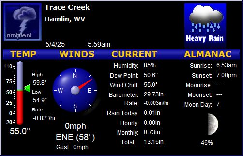
28.0 Deg; Hamlin Weather


Updated: 11:28pm on 2/8/10

Current Local Advisories
Warning Date: 10:35 PM EST on February 8, 2010   Warning Description: Winter Weather Advisory

(location)

Currently:
28.0

Clear
Overcast

High: 31.0° 
(4:12pm) 
Low: 21.4° 
(7:30am)
 
 
7 Day Forecast
If not updated CLICK HERE then refresh page.
Expires:201002091500;;664115
FPUS51 KRLX 090034
ZFPRLX
ZONE FORECAST PRODUCT FOR CENTRAL APPALACHIANS AND MIDDLE OHIO VALLEY
NATIONAL WEATHER SERVICE CHARLESTON WV
731 PM EST MON FEB 8 2010

WVZ013-091500-
LINCOLN-
INCLUDING THE CITIES OF...HARTS...ALUM CREEK...HAMLIN
731 PM EST MON FEB 8 2010
...WINTER WEATHER ADVISORY IN EFFECT FROM 5 AM TUESDAY TO 7 PM EST
WEDNESDAY...
.REST OF TONIGHT...CLOUDY. A CHANCE OF SNOW. NOT AS COLD. NEAR
STEADY TEMPERATURE IN THE UPPER 20S. EAST WINDS AROUND 5 MPH. CHANCE
OF SNOW 50 PERCENT. 
.TUESDAY...SNOW AND FREEZING RAIN IN THE MORNING...THEN RAIN IN THE
AFTERNOON. SNOW ACCUMULATION UP TO 1 INCH. ICE ACCUMULATION OF UP TO
ONE QUARTER OF AN INCH. HIGHS IN THE UPPER 30S. SOUTHEAST WINDS 5 TO
10 MPH. CHANCE OF PRECIPITATION NEAR 100 PERCENT. 
.TUESDAY NIGHT...RAIN WITH SNOW LIKELY IN THE EVENING...THEN SNOW
AFTER MIDNIGHT. SNOW ACCUMULATION AROUND AN INCH. COLD WITH LOWS
AROUND 20. SOUTH WINDS 10 TO 15 MPH. CHANCE OF PRECIPITATION
90 PERCENT. 
.WEDNESDAY...SNOW LIKELY. ADDITIONAL LIGHT SNOW ACCUMULATION
POSSIBLE. BRISK AND COLDER WITH HIGHS IN THE UPPER 20S. WEST WINDS
15 TO 20 MPH WITH GUSTS UP TO 30 MPH. CHANCE OF SNOW 70 PERCENT. 
.WEDNESDAY NIGHT...CLOUDY. A CHANCE OF SNOW IN THE EVENING...THEN A
CHANCE OF SNOW SHOWERS AFTER MIDNIGHT. COLD WITH LOWS IN THE LOWER
20S. WEST WINDS 10 TO 15 MPH WITH GUSTS UP TO 25 MPH. CHANCE OF SNOW
50 PERCENT. 
.THURSDAY...MOSTLY CLOUDY WITH A CHANCE OF SNOW SHOWERS IN THE
MORNING...THEN PARTLY SUNNY IN THE AFTERNOON. COLD WITH HIGHS IN THE
LOWER 30S. CHANCE OF SNOW 40 PERCENT. 
.THURSDAY NIGHT AND FRIDAY...PARTLY CLOUDY. LOWS 15 TO 20. HIGHS IN
THE LOWER 30S. 
.FRIDAY NIGHT THROUGH SATURDAY NIGHT...MOSTLY CLOUDY. COLD. LOWS
15 TO 20. HIGHS IN THE LOWER 30S. 
.SUNDAY THROUGH PRESIDENTS DAY...MOSTLY CLOUDY. HIGHS IN THE MID
30S. LOWS AROUND 20. 
$$

Select Weather Warnings

U.S Weather Warnings

WV School Closings

Weather Details and Extended Forecast
Updated every 30 minutes

Hamlin NOAA Forecast
NOAA Station Report
Charleston NOAA Radar
Weather Synopsis
Winter Forecast
Zoom Radar
Area Temperature Map (mesomap)
WV Ski Report
24 Hour weather loop
Web cam Photos
Web cam Time Lapse
2MB file size
2009 Time Lapse
15MB file size
Video Forecast
Weather Station Location
Teach's Hole
Silver Lake Harbor
OBX Radar
Surf Forecast
Free Desktop Weather Program
Weather Station Hardware
Weather Station Software
Webcam Software
Lincoln Journal News
Putnam Live News
Travel Photos
Free Speed Test
Suggestions? Email me
Weather Underground PWS KWVHAMLI2
Hourly Rain 0.0 in
Daily Rain: 0.0 in
Monthly Rain: 1.9 in
Yearly Rain: 4.3 in
Normal Rain, month to date: 1.9 in
Normal Rain, year to date: 4.4 in

StarDot NetCam

2 Day Outlook
TueNormal's
High 36°45°
Low 20°25°
Sleet
High Wind Today- 10 mph at (11:48am)
Wed
High 27°
Low 22°
Snow


Weather Underground Records
Historical Data

Daily High 31.0°
on 4:12pm
Daily Low 21.4°
on 7:30am
24 Hours Ago 23.1°
Difference 4.9°
Todays Avg. 26.1°
000
Yesterday's High 27.5°
at 12:00am
Yesterday's Low 21.2°
at 6:10am°
Monthly High 40.9°
on 2/4/10
Monthly Low 7.8°
on 2/1/10
000
Monthly Avg. 30.3°
Yearly Avg. 29.3°
000
2009 Records
High 55.6° 
 1/19/10
Low -2.2° 
 1/31/10


Non-Looping Map (465K)

Radar Status

WV Advisory
Charleston Area:
Warning Description: Winter Weather Advisory

Warning Date: 10:35 PM EST on February 8, 2010

WarningSum:...Winter Weather Advisory Remains In Effect From 5 Am Tuesday To
7 Pm Est Wednesday...

Warning Message:A Winter Weather Advisory remains in effect from 5 am Tuesday to
7 PM EST Wednesday. 
A low pressure system will move northeast on Tuesday.
Precipitation...associated with this system...should overspread
the region early Tuesday morning...and then continue into
Wednesday afternoon. 
Snow at the start could accumulate an inch or two by dawn
Tuesday...especially across west central West Virginia including
the Huntington to Charleston corridor. Otherwise...the
precipitation will take the form of a mixture of snow...sleet and
freezing rain Tuesday morning.
Warmer air should result in the precipitation changing to rain by
early Tuesday afternoon. Before the precipitation changes over...
up to another inch of snow and a light coating of ice is possible.
The precipitation should then change back to all snow late Tuesday
afternoon and early Tuesday evening...as colder air filters back
into the area. The snow should then taper off to snow showers
Wednesday evening.
Total snow accumulations from late Tuesday afternoon through
Wednesday afternoon will range from 3 to 5 inches....with locally
higher amounts.
A Winter Weather Advisory means that periods of snow...sleet...or
freezing rain will cause travel difficulties. Be prepared for
slippery roads and limited visibilities...and use caution while
driving.
        

Canaan Valley:
Warning Description: Winter Storm Warning

Warning Date: 9:16 PM EST on February 8, 2010

WarningSum:...Winter Storm Warning Remains In Effect From 7 Am Tuesday To
7 Pm Est Wednesday...

Warning Message:A Winter Storm Warning remains in effect from 7 am Tuesday to
7 PM EST Wednesday. 
A low pressure system will develop across the Ohio Valley early
Tuesday morning. This low...combined with another low developing
across the southern Gulf states will pull additional moisture
into the region. This system will allow for snow...which may be
heavy at times...to push into the area starting Tuesday morning
and continue into Wednesday. Through Wednesday evening...storm
total snow accumulation of 10 to 16 inches can be expected.
As the storm moves east of the area Wednesday afternoon...brisk
northwesterly winds will begin to gust to 20 to 30 mph with snow
showers continuing. This will allow for blowing and drifting snow
to develop.
A Winter Storm Warning for heavy snow means severe winter weather
conditions are expected or occurring.  Significant amounts of
snow are forecast that will make travel dangerous and impact snow
clearing and power restoration efforts. Only travel in an
emergency. If you must travel...keep an extra flashlight...
food...and water in your vehicle in case of an emergency. When
snow begins Tuesday report your snowfall accumulations to the
National Weather Service by calling toll free...1-877-633-6772.
Warning Description: Special Weather Statement

Warning Date: 10:19 PM EST on February 8, 2010

WarningSum:...Icy Roads Can Be Expected Again Tonight...

Warning Message:The National Weather Service says travelers must continue to be
alert for icy pavement overnight. As Road crews work to clear
snow off of area roadways...sunny skies today allowed for some
melting of leftover snow. With temperatures remaining below
freezing tonight...untreated pavement can become icy. Although
roads may appear to be clear...black ice remains a threat. Be
cautious while driving and allow extra time to reach your
destination.
        

Pope Valley CA Advisory
No Warnings
Ocracoke Island
No Warnings
NYC/NJ Metro Advisory
Warning Description: Winter Storm Watch

Warning Date: 10:35 PM EST on February 8, 2010

WarningSum:...Winter Storm Watch Remains In Effect From Tuesday Evening
Through Late Wednesday Night...

Warning Message:A Winter Storm Watch remains in effect from Tuesday evening
through late Wednesday night. 
Snow is expected to overspread the region starting late Tuesday
evening. The snow may become heavy at times on Wednesday...before
slowly tapering off Wednesday night.
The potential for 6 to 12 inches of snow accumulation exists. At
this time the higher amounts are expected across the New York
City metropolitan area and Long Island.
As the storm intensifies...east to northeast winds will become
strong and gusty during the day on Wednesday...with gusts up to
45 mph possible especially in coastal sections. This will cause
blowing and drifting of snow...with near blizzard conditions and
possible power outages.
Precautionary/preparedness actions...
A Winter Storm Watch means there is a potential for significant
snow...sleet...or ice accumulations that may impact travel.
Continue to monitor the latest forecasts.
        

Find the Weather for any City, State  
or Zipcode, or Country:

click tracking


Visitor Map
Create your own visitor map!